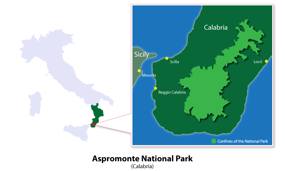
Skip to content
Places / National Parks / Aspromonte National Park
Aspromonte

Aspromonte

Published: Updated:

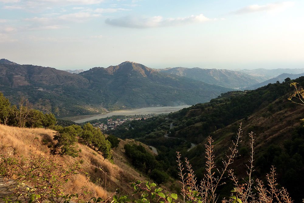
A vast national park, teeming with nature, covered in beautiful flora and trees, punctuated by sprawling rivers and streams, the Aspromonte National Park is situated in the southern section of the Apennines, in Calabria, Italy.

Aspromonte National Park
click to enlarge

The name Aspromonte means rough mountains, and it’s an apt description. The national park is near the sea, down in the “toe” of Italy’s boot and includes many mountains, the tallest Montalto reaching up to 1,955 metres. Boasting wildlife such as wolves, peregrine falcons, eagle owls, goshawks and deers. Not just teeming with nature, Aspromonte park flourishes with beech trees and silver firs, interspersed with glorious black pines, oaks and chestnuts with delightful rare plants scattered over her hills and mountains.

This lush palace of nature is rich in more than wildlife, the park has a fascinating history, The 76,000 hectares now home to abandoned villages, and it’s thick forests have been the scene of many a battle and the refuge for those fleeing. It has seen the Greeks and witnessed the defeat of Garibaldi by Italian troops when he attempted to seize power and acquire the Papal states for the newly united Italy. The park was also the home territory of the ‘ndrangheta - band of peasant families who rebelled against rich landowners by stealing their animals and blackmailing the elite.

The ‘ndrangheta made use of the tall, almost inaccessible mountain range as a hiding place for the unlucky victims of their kidnap schemes and as a lair for their contraband.Until it was established as Italy’s 6th national park in 1989 it had been the scene of uprisings, wars and home to several villages.

Nowadays the Aspromonte is quiet, home only to mother nature’s secret beauty spots.

The Aspromonte is a veritable goldmine of terrific trails, wondrous walks and magnificent meanderings. The locals are welcoming, the views are vast and the park has remained unblemished by mass tourism to this day.

Her rugged plains stretch from the Tyrrhenian to the Ionian Sea. And her perfect weather conditions encourage biodiversity on a stunning scale. The winding waterways snaking their way across the Apostromonte in great abundance, lead to the flourishing of lush vegetation, flora and trees, look out for the rare citrus fruits perfuming the air around you.

Nature lovers must put the Aspromonte on their list of places to see in Italy. Walk the forest paths and marvel at wild cats and dormouse, along with wild boar and gorgeous black squirrels darting along the tree boughs. Delight as you see foxes frolicking around you, hares and badgers scampering through the bushes, hedgehogs, weasels and martens flitting about before you. But keep your joyous exclamations down - you’ll scare off all the deer. Re-introduced in 2011 after years of absence, the Aspromonte is home to the roe deer. Apart from all the wonderful nature trails, you can bike, canoe and sail.

The tourist facilities are relatively few but all are wheelchair accessible. Nature has been allowed to rule as she pleases, and the results are a sight to behold. Rocky slopes fall sharply into the shimmering Mediterranean. Steep mountains drape down, creating plains, and fields fenced by sky scraping peaks. Gorges cuddle rivers and waterfalls, surprises are around every bend and there’s no way you could experience it all in one day.

Some of the waterfalls are there all year round, but others have to be caught after the rainy season in the winter.

If you’re a bird lover, you can’t miss this haven with many rare birds that won’t be seen anywhere else in Italy. The Black woodpecker and the Bonelli eagle make the Asporomonte their home but the region is also the focal migration point of this side of Europe, for birds crossing the Mediterranean. In the Autumn, the birds flock here in their hundreds to make the crossing.

Meandering the forests you’ll encounter ruins and remnants of the Greeks. Persephone’s temple walls, trenches and fortifications and if you make it to the centre Pietra Cappa - you will find Byzantium monasteries. Churches dot the region in various staples of a range of time periods.

The whole Aspromonte region is perfumed by the Jasmine orchards, which are actually used extensively by the perfume industry.

If you’re looking for a souvenir on your way home, why not purchase some of the region’s special wood carved pipes or kitchen tools?

Whatever you’re looking for, the Aspromonte is a hub of glorious nature, undisturbed by the over “tourisication.” It remains a paradise of nature that cannot be missed.

Places Dossier

Places icon

Italy

A compact place-reference: regions, settlements, landscapes, protected areas, and heritage — designed to sit beneath articles.

Regions Towns & Cities Landscapes Heritage
Italy — places feature image
Italy by territory: how the country breaks down, what to look for, and how landscapes and heritage shape the map.

Italy — places snapshot

Stable reference signals for quick geographic orientation.

Regions

20

Five have special autonomous status, reflecting distinct languages, history, and geography. Regions shape administration, services, and identity — often the most useful “map unit” for travellers and readers.

2nd-level

110

Provinces and metropolitan city authorities that coordinate planning, roads, schools, and territorial services. The role varies by area, but they remain a key layer between region and comune.

Comuni

7,904

The municipal building blocks of Italy — cities, towns, villages, and mountain communities. Local identity is strongly comune-based, and many services and permissions are handled at this level.

National parks

25

State-level protected areas covering alpine massifs, forests, volcanic zones, islands, and coastlines. They anchor biodiversity protection and define some of Italy’s most distinctive natural landscapes.

Highest peak

~4,806 m

Mont Blanc (Monte Bianco) on the border with France — the highest summit in the Alps. Italy’s high mountains influence climate, watersheds, and seasonal travel patterns across the north.

Largest lake

~370 km²

Lake Garda, spanning multiple regions, is the largest Italian lake by surface area. Northern lakes act as microclimate zones and long-standing settlement and resort corridors.

Longest river

652 km

The Po runs west–east across the northern plain, shaping agriculture, industry, and major transport routes. It defines Italy’s largest lowland system and a dense belt of settlement and production.

UNESCO

61

World Heritage properties spread across historic centres, archaeological sites, cultural landscapes, and natural areas. The density of listed places makes heritage a visible, lived layer of the national territory.

Regions

Twenty Italies, one map

Regions are the primary lens for variation: dialects, food cultures, building styles, and everyday rhythms often track regional boundaries. They also structure administration and public services, so “where you are” has practical effects as well as cultural ones. For orientation, region is often the fastest way to understand the landscape, the cuisine, and the character of a place.

Towns & Cities

A network of centres

Italy is organised as a network of historic cities and thousands of comuni rather than a single dominant urban core. Larger cities concentrate infrastructure and institutions, while smaller towns preserve local craft, festivals, and distinctive street patterns. This creates short-distance variety: a few kilometres can shift language, architecture, food, and landscape.

Landscapes

Mountains, plains, coasts

The Alps and Apennines frame the country, with plains, lakes, islands, and long coastlines producing sharp local contrasts. Terrain shapes climate, agriculture, and settlement density — and it also governs travel time far more than straight-line distance suggests. Italy’s landscape is best read as a mosaic of micro-regions, each with its own feel and seasonal rhythm.

Heritage

Layers you can visit

Heritage in Italy is embedded: Roman routes, medieval walls, and Renaissance centres are often part of living neighbourhoods. Archaeology appears both as major sites and as fragments — a column, a gate, a street plan — folded into modern life. The experience is less “museum-only” and more a continuous encounter with past layers in active places.

Italy regions
Regions
Italy towns and cities
Towns & Cities
Italy landscapes
Landscapes
Italy heritage sites
Heritage
Italy national parks, lakes, rivers and mountains

Natural

Parks, peaks, water, islands

Italy’s protected landscapes range from alpine ridgelines and deep forests to volcanic terrain and island coastlines. National parks anchor biodiversity and define some of the country’s most iconic routes and viewpoints, while lakes and rivers organise settlement and mobility corridors. The natural map explains climate shifts, local agriculture, and why certain places became historic crossroads, resort zones, or remote refuges.

Italy archaeological sites

Archaeology

From ruins to living streets

Archaeology in Italy is geographic: Greek colonies in the south, Etruscan centres in central regions, Roman infrastructure nationwide, and medieval layers almost everywhere. Some sites are monumental, but many traces appear as everyday fragments — walls, gates, amphitheatres, road alignments — integrated into modern towns. This is why “place” in Italy often includes time: landscapes and settlements carry multiple eras in the same view.