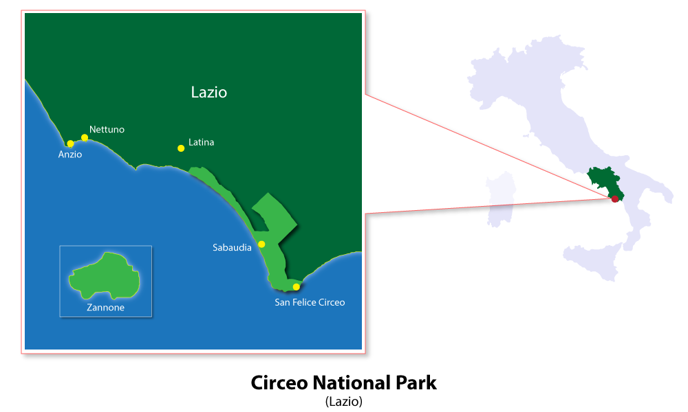
Skip to content
Places / National Parks / Circeo National Park
Circeo

Circeo

Published:

Circeo National Park, located along the Tyrrhenian coast, is one of the oldest national parks in Italy. The park is located in between the city of Terracina and the fishing town of Anzio, around 100km from Rome.

Circeo National Park
click to enlarge

The park is of significant naturalistic, hydrogeological and faunal interest, and is protected by the state. Current challenges for the park are tourism, as well as eutrophication and sewage pollution.

When the Pontine Marshes were drained in the 1920s, along with the clearing of its forests, many wetland ecosystems were lost in the process. In order to retain the preservation of the Pontines, Benito Mussolini ordered the land around Mount Circeo to become a National Park. It is now officially a UNESCO Biosphere Reserve.

Whilst the park was only opened in 1934, human presence on the land can be traced back to the Middle Paleolithic era. In fact, a perfectly intact Neanderthal skull was discovered in the area!

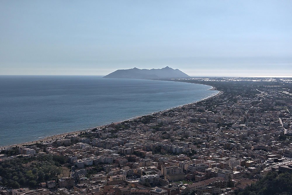
The park is made up of five distinct habitats: the dunes, wetlands, forest, Zannone Island, and the promontory. The sand dunes are a magnificent sight and extend for 25 km along the coast. The lagoon wetlands contain four coastal lakes and contain over 260 bird species.

Circeo’s forest is the largest flat forest in Italy and is home to a huge variety of fauna and flora. Visitors to Selva di Circe, one of the world’s most beautiful forests, may also have a rare opportunity to see a wild boar up close.

Zannone Island is a 1 square kilometre island boasting several rare biomes and is home to hundreds of feral wild sheep, and finally, Mount Circeo, a marl and sandstone mountain, is home to one of the biggest Neanderthal findings, as well as a key location in Homer’s Odyssey. The island also has ancient rocks dating back 200 million years.

The park works as a perfect ecosystem, with each habitat playing a vital role. The coastal dunes protect the forest from the winds, whilst migratory birds seek rest and shelter in the park’s wetlands.

The park’s towns are all widely unique. The pretty San Felice Circeo proudly hosts sea caves, scuba diving and seafood restaurants. The views from the town are also spectacular. Sabuadia is a seaside city and visitors can partake in sporting activities, such as rowing.

Around the five habitats there is plenty to do such as horse riding; long, scenic bike rides; watersports; canoeing; sailing and sunbathing.

The park derives its name, of course, from Mount Circeo. The mountain is named after ancient sorceress Circe, the daughter of Helois and Perse, who had the ability to turn humans into lions, wolves and pigs.

According to Odyssey, she invited Odysseus back to her cave in the mountain for a year-long love affair. Rumours has it she still lives on the mountain, looking down at Circeo, with the men always at risk of being turned into swine.

Places Dossier

Places icon

Italy

A compact place-reference: regions, settlements, landscapes, protected areas, and heritage — designed to sit beneath articles.

Regions Towns & Cities Landscapes Heritage
Italy — places feature image
Italy by territory: how the country breaks down, what to look for, and how landscapes and heritage shape the map.

Italy — places snapshot

Stable reference signals for quick geographic orientation.

Regions

20

Five have special autonomous status, reflecting distinct languages, history, and geography. Regions shape administration, services, and identity — often the most useful “map unit” for travellers and readers.

2nd-level

110

Provinces and metropolitan city authorities that coordinate planning, roads, schools, and territorial services. The role varies by area, but they remain a key layer between region and comune.

Comuni

7,904

The municipal building blocks of Italy — cities, towns, villages, and mountain communities. Local identity is strongly comune-based, and many services and permissions are handled at this level.

National parks

25

State-level protected areas covering alpine massifs, forests, volcanic zones, islands, and coastlines. They anchor biodiversity protection and define some of Italy’s most distinctive natural landscapes.

Highest peak

~4,806 m

Mont Blanc (Monte Bianco) on the border with France — the highest summit in the Alps. Italy’s high mountains influence climate, watersheds, and seasonal travel patterns across the north.

Largest lake

~370 km²

Lake Garda, spanning multiple regions, is the largest Italian lake by surface area. Northern lakes act as microclimate zones and long-standing settlement and resort corridors.

Longest river

652 km

The Po runs west–east across the northern plain, shaping agriculture, industry, and major transport routes. It defines Italy’s largest lowland system and a dense belt of settlement and production.

UNESCO

61

World Heritage properties spread across historic centres, archaeological sites, cultural landscapes, and natural areas. The density of listed places makes heritage a visible, lived layer of the national territory.

Regions

Twenty Italies, one map

Regions are the primary lens for variation: dialects, food cultures, building styles, and everyday rhythms often track regional boundaries. They also structure administration and public services, so “where you are” has practical effects as well as cultural ones. For orientation, region is often the fastest way to understand the landscape, the cuisine, and the character of a place.

Towns & Cities

A network of centres

Italy is organised as a network of historic cities and thousands of comuni rather than a single dominant urban core. Larger cities concentrate infrastructure and institutions, while smaller towns preserve local craft, festivals, and distinctive street patterns. This creates short-distance variety: a few kilometres can shift language, architecture, food, and landscape.

Landscapes

Mountains, plains, coasts

The Alps and Apennines frame the country, with plains, lakes, islands, and long coastlines producing sharp local contrasts. Terrain shapes climate, agriculture, and settlement density — and it also governs travel time far more than straight-line distance suggests. Italy’s landscape is best read as a mosaic of micro-regions, each with its own feel and seasonal rhythm.

Heritage

Layers you can visit

Heritage in Italy is embedded: Roman routes, medieval walls, and Renaissance centres are often part of living neighbourhoods. Archaeology appears both as major sites and as fragments — a column, a gate, a street plan — folded into modern life. The experience is less “museum-only” and more a continuous encounter with past layers in active places.

Italy regions
Regions
Italy towns and cities
Towns & Cities
Italy landscapes
Landscapes
Italy heritage sites
Heritage
Italy national parks, lakes, rivers and mountains

Natural

Parks, peaks, water, islands

Italy’s protected landscapes range from alpine ridgelines and deep forests to volcanic terrain and island coastlines. National parks anchor biodiversity and define some of the country’s most iconic routes and viewpoints, while lakes and rivers organise settlement and mobility corridors. The natural map explains climate shifts, local agriculture, and why certain places became historic crossroads, resort zones, or remote refuges.

Italy archaeological sites

Archaeology

From ruins to living streets

Archaeology in Italy is geographic: Greek colonies in the south, Etruscan centres in central regions, Roman infrastructure nationwide, and medieval layers almost everywhere. Some sites are monumental, but many traces appear as everyday fragments — walls, gates, amphitheatres, road alignments — integrated into modern towns. This is why “place” in Italy often includes time: landscapes and settlements carry multiple eras in the same view.