Skip to content
Places / Regional Features / Campania / Herculaneum
Herculaneum

Herculaneum

Published:

Nestled in the shadow of Mount Vesuvius, Herculaneum remains one of the most fascinating archaeological sites in Italy, offering a unique glimpse into the daily life and tragic end of a Roman city. Unlike its more famous neighbor, Pompeii, Herculaneum was buried under a far denser and hotter pyroclastic material during the catastrophic eruption in 79 AD. This led to better preservation of organic materials, such as wood, food, and even fabrics, which provides us with an incomparable window into the ancient world.

The Discovery and Excavation of Herculaneum

The story of Herculaneum's modern discovery begins in the early 18th century, although the site had been occasionally plundered by tunneling thieves for centuries. Official excavations started under the auspices of the King of Naples in 1738, predating the work in Pompeii by about a decade. Early excavation techniques were primitive and often destructive; it wasn't until the 20th century that more systematic and scientifically informed methods were employed.

The excavation of Herculaneum has been a complex process due to the deep volcanic material that covers the site, which solidified into a hard rock-like layer. This has preserved upper levels of buildings and delicate structures that are not seen in Pompeii, but it also makes the excavation efforts much more challenging and time-consuming.

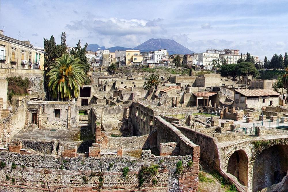
Daily Life in Herculaneum

The remains of Herculaneum provide a snapshot of Roman life in the 1st century AD. The city was smaller than Pompeii but wealthier, which is reflected in the high quality of the homes and public buildings. Many of the houses in Herculaneum boasted intricate mosaics, fine wall paintings, and a complex water system.

One of the most notable residences is the House of the Mosaic Atrium, which showcases a large, beautifully detailed mosaic floor and sophisticated wall paintings. Public baths, complete with heated floors and walls, also speak to the community's affluence.

The social structure of Herculaneum can be glimpsed through the artifacts that have been recovered. Items such as household utensils, jewelry, and even carbonized food give us insight into the daily activities and social practices of its residents. These finds suggest a community that enjoyed a comfortable lifestyle with a taste for luxury and beauty.

The Catastrophe of 79 AD

The eruption of Mount Vesuvius in 79 AD was a monumental event that buried Herculaneum under approximately 20 meters (65 feet) of volcanic material. The rapid burial helped preserve the town, but it also sealed the fate of its inhabitants. Unlike Pompeii, where many residents were killed by falling buildings or ash suffocation, most of Herculaneum's citizens perished due to the intense heat of the pyroclastic flows.

Excavations have uncovered skeletal remains in the boat chambers at the ancient shoreline, where people apparently sought refuge, hoping to escape by sea. This grim discovery provides a poignant reminder of the disaster's human cost.

Archaeological Discoveries and Their Significance

Archaeologists have unearthed a wealth of artifacts in Herculaneum that have significantly contributed to our understanding of Roman technologies, arts, and daily life. Notably, the discovery of the Herculaneum papyri (carbonized scrolls) in the Villa of the Papyri has opened a new window into ancient literature and philosophy. These scrolls are still being deciphered and hold the potential to reshape our knowledge of the ancient world.

Furthermore, the preservation of organic materials has allowed researchers to conduct detailed analyses of the diet and health of the ancient Romans. Studies of preserved food have revealed a varied diet that included fruits, nuts, cheese, and fish, providing insight into the agricultural practices and trade networks of the time.

Herculaneum Today

Today, Herculaneum is a UNESCO World Heritage site and a popular tourist destination. Efforts to preserve the site are ongoing, with new technologies being employed to protect the ruins from environmental and human-induced threats. Tourists visiting Herculaneum can walk the ancient streets almost as if they were Roman citizens themselves, peering into shops and homes, and standing in the very spaces where Herculaneum's residents lived their daily lives until Vesuvius's catastrophic eruption changed everything in an instant.

Conclusion

Herculaneum offers a unique perspective on the Roman world, its preservation providing a more intimate and detailed view than nearly any other archaeological site of its kind. As excavations continue and technologies evolve, the ancient city is sure to reveal even more about the Roman world. For historians, archaeologists, and visitors alike, Herculaneum remains a poignant testament to the fragility of human life and the enduring quest to understand our past.

Places Dossier

Places icon

Italy

A compact place-reference: regions, settlements, landscapes, protected areas, and heritage — designed to sit beneath articles.

Regions Towns & Cities Landscapes Heritage
Italy — places feature image
Italy by territory: how the country breaks down, what to look for, and how landscapes and heritage shape the map.

Italy — places snapshot

Stable reference signals for quick geographic orientation.

Regions

20

Five have special autonomous status, reflecting distinct languages, history, and geography. Regions shape administration, services, and identity — often the most useful “map unit” for travellers and readers.

2nd-level

110

Provinces and metropolitan city authorities that coordinate planning, roads, schools, and territorial services. The role varies by area, but they remain a key layer between region and comune.

Comuni

7,904

The municipal building blocks of Italy — cities, towns, villages, and mountain communities. Local identity is strongly comune-based, and many services and permissions are handled at this level.

National parks

25

State-level protected areas covering alpine massifs, forests, volcanic zones, islands, and coastlines. They anchor biodiversity protection and define some of Italy’s most distinctive natural landscapes.

Highest peak

~4,806 m

Mont Blanc (Monte Bianco) on the border with France — the highest summit in the Alps. Italy’s high mountains influence climate, watersheds, and seasonal travel patterns across the north.

Largest lake

~370 km²

Lake Garda, spanning multiple regions, is the largest Italian lake by surface area. Northern lakes act as microclimate zones and long-standing settlement and resort corridors.

Longest river

652 km

The Po runs west–east across the northern plain, shaping agriculture, industry, and major transport routes. It defines Italy’s largest lowland system and a dense belt of settlement and production.

UNESCO

61

World Heritage properties spread across historic centres, archaeological sites, cultural landscapes, and natural areas. The density of listed places makes heritage a visible, lived layer of the national territory.

Regions

Twenty Italies, one map

Regions are the primary lens for variation: dialects, food cultures, building styles, and everyday rhythms often track regional boundaries. They also structure administration and public services, so “where you are” has practical effects as well as cultural ones. For orientation, region is often the fastest way to understand the landscape, the cuisine, and the character of a place.

Towns & Cities

A network of centres

Italy is organised as a network of historic cities and thousands of comuni rather than a single dominant urban core. Larger cities concentrate infrastructure and institutions, while smaller towns preserve local craft, festivals, and distinctive street patterns. This creates short-distance variety: a few kilometres can shift language, architecture, food, and landscape.

Landscapes

Mountains, plains, coasts

The Alps and Apennines frame the country, with plains, lakes, islands, and long coastlines producing sharp local contrasts. Terrain shapes climate, agriculture, and settlement density — and it also governs travel time far more than straight-line distance suggests. Italy’s landscape is best read as a mosaic of micro-regions, each with its own feel and seasonal rhythm.

Heritage

Layers you can visit

Heritage in Italy is embedded: Roman routes, medieval walls, and Renaissance centres are often part of living neighbourhoods. Archaeology appears both as major sites and as fragments — a column, a gate, a street plan — folded into modern life. The experience is less “museum-only” and more a continuous encounter with past layers in active places.

Italy regions
Regions
Italy towns and cities
Towns & Cities
Italy landscapes
Landscapes
Italy heritage sites
Heritage
Italy national parks, lakes, rivers and mountains

Natural

Parks, peaks, water, islands

Italy’s protected landscapes range from alpine ridgelines and deep forests to volcanic terrain and island coastlines. National parks anchor biodiversity and define some of the country’s most iconic routes and viewpoints, while lakes and rivers organise settlement and mobility corridors. The natural map explains climate shifts, local agriculture, and why certain places became historic crossroads, resort zones, or remote refuges.

Italy archaeological sites

Archaeology

From ruins to living streets

Archaeology in Italy is geographic: Greek colonies in the south, Etruscan centres in central regions, Roman infrastructure nationwide, and medieval layers almost everywhere. Some sites are monumental, but many traces appear as everyday fragments — walls, gates, amphitheatres, road alignments — integrated into modern towns. This is why “place” in Italy often includes time: landscapes and settlements carry multiple eras in the same view.