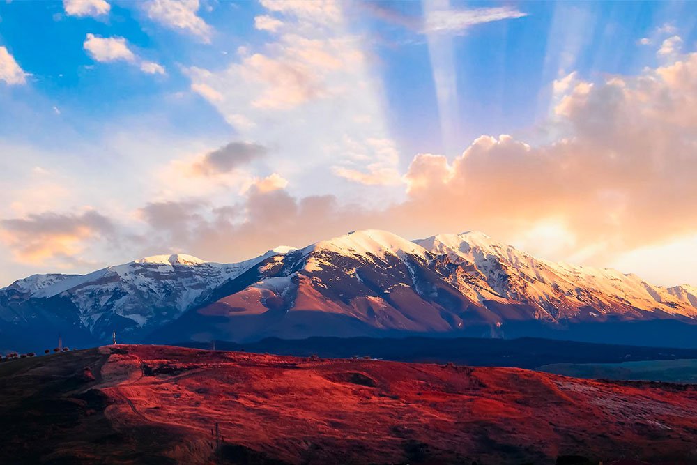
Skip to content
Places / National Parks / Majella National Park
Majella

Majella

Published:

Majella National Park (Parco Nazionale della Maiella) is a 740 square-kilometre sized park located between the provinces of Chieti, Pescara and L’Aquila. The park is located high above sea level with over half of the land having an altitude of over 2,000 metres. This huge altitude helps to make Majella the second-highest mountain massif in the Apennines.

Majella National Park
click to enlarge

The park’s most notable mountains are Monte Porrara, the Pizi mountains and the mountains of Morrone and Mount Amaro, which is 2,800 metres high and the highest peak in Majella. There are 180 named mountains in the park.

The park is lucky enough to have over 2,000 species of flora; a third of all plant species present in Italy. Some highlights are the sticky-leaved pinguicula del Fiore, the thistle-like Centaurea tenoreana Willk and the Least Snowbell (Soldanella minima).

Tourists can visit several main sights in the park including the Grotta Sant'Angelo cave paintings, one of the deepest caves in Europe, Grotta del Cavallone. There are several tourist centres located throughout.

A must-see for the park is the Hermitage of San Michele in Pescocostanzo, dedicated to the archangel, St Michael. This is a small cave church, previously the home of Pietro da Morrone, a hermit who went on to become Pope Celestine V. After his death, the dwelling was transformed into a church.

The park is also known for its 500 km of hiking trails through the mountains. Some of the highlights include Majella’s historic town Roccacaramanico, a very snowy medieval village. It is a 'ghost hamlet' in that by the 1980s, the population had dwindled to just one resident. However, the population is now again on the rise.

At the foothills of the Majella mountain lies the town of Guardiagrele, a town listed as 'borghi più belli d'Italia' (one of the most beautiful towns in Italy) and known for copper, jeweller’s art and wrought-iron crafts. Be sure to also roam the Avello Valley. This deep valley has picturesque views of the surrounding area, as well as canyons and caves.

The most notable animal in the park is the Apennine wolf. There are about 10 packs in the Majella, approximately 70 - 80 individuals which makes it one of the largest populations in the world. The symbol of a wolf acts as the park’s logo.

Other unique animals living in the park are golden eagles, peregrine falcons, as well as an approximate population of twenty Marsican brown bears. The venomous Orsini’s viper snake, the red-billed chough, the European pine marten, the Corsican hare and the very rare European otter.

Majella is a UNESCO Global Geopark which, between 1998 and 2005, was the focus of a geoscientific research project, TaskForceMajella (TFM). The project examined geological structure and analysed fractures and faults. It was also one of 12 PAN Parks, which worked to preserve European areas of wilderness. However, the company is currently in liquidation.

Places Dossier

Places icon

Italy

A compact place-reference: regions, settlements, landscapes, protected areas, and heritage — designed to sit beneath articles.

Regions Towns & Cities Landscapes Heritage
Italy — places feature image
Italy by territory: how the country breaks down, what to look for, and how landscapes and heritage shape the map.

Italy — places snapshot

Stable reference signals for quick geographic orientation.

Regions

20

Five have special autonomous status, reflecting distinct languages, history, and geography. Regions shape administration, services, and identity — often the most useful “map unit” for travellers and readers.

2nd-level

110

Provinces and metropolitan city authorities that coordinate planning, roads, schools, and territorial services. The role varies by area, but they remain a key layer between region and comune.

Comuni

7,904

The municipal building blocks of Italy — cities, towns, villages, and mountain communities. Local identity is strongly comune-based, and many services and permissions are handled at this level.

National parks

25

State-level protected areas covering alpine massifs, forests, volcanic zones, islands, and coastlines. They anchor biodiversity protection and define some of Italy’s most distinctive natural landscapes.

Highest peak

~4,806 m

Mont Blanc (Monte Bianco) on the border with France — the highest summit in the Alps. Italy’s high mountains influence climate, watersheds, and seasonal travel patterns across the north.

Largest lake

~370 km²

Lake Garda, spanning multiple regions, is the largest Italian lake by surface area. Northern lakes act as microclimate zones and long-standing settlement and resort corridors.

Longest river

652 km

The Po runs west–east across the northern plain, shaping agriculture, industry, and major transport routes. It defines Italy’s largest lowland system and a dense belt of settlement and production.

UNESCO

61

World Heritage properties spread across historic centres, archaeological sites, cultural landscapes, and natural areas. The density of listed places makes heritage a visible, lived layer of the national territory.

Regions

Twenty Italies, one map

Regions are the primary lens for variation: dialects, food cultures, building styles, and everyday rhythms often track regional boundaries. They also structure administration and public services, so “where you are” has practical effects as well as cultural ones. For orientation, region is often the fastest way to understand the landscape, the cuisine, and the character of a place.

Towns & Cities

A network of centres

Italy is organised as a network of historic cities and thousands of comuni rather than a single dominant urban core. Larger cities concentrate infrastructure and institutions, while smaller towns preserve local craft, festivals, and distinctive street patterns. This creates short-distance variety: a few kilometres can shift language, architecture, food, and landscape.

Landscapes

Mountains, plains, coasts

The Alps and Apennines frame the country, with plains, lakes, islands, and long coastlines producing sharp local contrasts. Terrain shapes climate, agriculture, and settlement density — and it also governs travel time far more than straight-line distance suggests. Italy’s landscape is best read as a mosaic of micro-regions, each with its own feel and seasonal rhythm.

Heritage

Layers you can visit

Heritage in Italy is embedded: Roman routes, medieval walls, and Renaissance centres are often part of living neighbourhoods. Archaeology appears both as major sites and as fragments — a column, a gate, a street plan — folded into modern life. The experience is less “museum-only” and more a continuous encounter with past layers in active places.

Italy regions
Regions
Italy towns and cities
Towns & Cities
Italy landscapes
Landscapes
Italy heritage sites
Heritage
Italy national parks, lakes, rivers and mountains

Natural

Parks, peaks, water, islands

Italy’s protected landscapes range from alpine ridgelines and deep forests to volcanic terrain and island coastlines. National parks anchor biodiversity and define some of the country’s most iconic routes and viewpoints, while lakes and rivers organise settlement and mobility corridors. The natural map explains climate shifts, local agriculture, and why certain places became historic crossroads, resort zones, or remote refuges.

Italy archaeological sites

Archaeology

From ruins to living streets

Archaeology in Italy is geographic: Greek colonies in the south, Etruscan centres in central regions, Roman infrastructure nationwide, and medieval layers almost everywhere. Some sites are monumental, but many traces appear as everyday fragments — walls, gates, amphitheatres, road alignments — integrated into modern towns. This is why “place” in Italy often includes time: landscapes and settlements carry multiple eras in the same view.