Skip to content
Places / National Parks / Pantelleria National Park
Pantelleria

Pantelleria

Published:

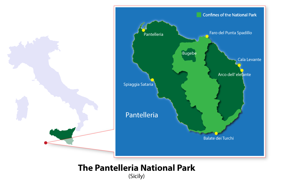
Pantelleria National Park (Parco Nazionale Isola de Pantelleria in Italian) is a national park on the island of Pantelleria, in Sicily. The 66.4 square kilometres national park, which covers 80% of the 84.5 square kilometre island, is Sicily’s first.

Pantelleria National Park
click to enlarge

The Mediterranean island was developed after a volcanic eruption 500,000 years ago. However, many of its physical formations stem from a volcanic eruption in 6,000 BC. Part of the park’s beauty is natural, with sections of the national park completely untouched.

An ideal starting point for tourists is the visitors’ centre located at Punta Spadillo, near the island’s lighthouse. They can then go on to visit archaeological sites such as late Roman and Bronze Age settlements. There is also an Acropolis dating back to Punic times.

The national park also hosts the majestic and mysterious Mirror Lake of Venus, where it said Venus herself used to gaze at her own reflection. The crystal-clear blue water lies in a volcano crater and is heated by underground springs up to between 40 and 50 degrees Celsius. Many people swim for free in the lake, attracted by its sulfur and mineral elements which are good for skin care and healing.

Pantelleria’s main heritage is its agriculture, developed through many generations of vine growers and farmers. The island has a tradition of cultivating head-trained bush vines on a plot of land owned by around 5,000 people, a process officially titled vite ad alberello. In 2014, this was added to the UNESCO Intangible Cultural Heritage list.

In 2018, the dry-stone walls of Pantelleria (paesaggio della pietra a secco di Pantelleria) was listed in the National Register of Historic Rural Landscapes (Registro Nazionale dei Paesaggi Rurali Storici).

The national park is awash with rich fauna and flora. There are roughly 640 species of flora, including 13 endemisms and 63 rare and very rare species. Whilst the fauna population has not been completely recorded, it is known that there are 1096 different species of arthropods, 14 endemisms and 260 species of birds, including the very rare Iberian zitting cisticola and Algerian blue tit.

As you would expect, the landmarks and landscapes seen in Pantelleria are completely unique. One main feature of the national park, in its many city quarters and Municipalities, is the inimitable dammuso housing. The dammuso, which has been around since the 10th century, is a thick-walled single-storey dwelling, made from volcanic rock. The structure keeps the interior cool and also allows for traditional domed roofs. Many of these have now been adapted and modernised for tourists.

The meticulous practice, which has been developed and maintained in the land’s local dialect, sees a summer harvest followed by many social events to celebrate the completion of the process. The local dialect in the park is Pantesco, a dialect of Sicilian influenced by Arabic.

Places Dossier

Places icon

Italy

A compact place-reference: regions, settlements, landscapes, protected areas, and heritage — designed to sit beneath articles.

Regions Towns & Cities Landscapes Heritage
Italy — places feature image
Italy by territory: how the country breaks down, what to look for, and how landscapes and heritage shape the map.

Italy — places snapshot

Stable reference signals for quick geographic orientation.

Regions

20

Five have special autonomous status, reflecting distinct languages, history, and geography. Regions shape administration, services, and identity — often the most useful “map unit” for travellers and readers.

2nd-level

110

Provinces and metropolitan city authorities that coordinate planning, roads, schools, and territorial services. The role varies by area, but they remain a key layer between region and comune.

Comuni

7,904

The municipal building blocks of Italy — cities, towns, villages, and mountain communities. Local identity is strongly comune-based, and many services and permissions are handled at this level.

National parks

25

State-level protected areas covering alpine massifs, forests, volcanic zones, islands, and coastlines. They anchor biodiversity protection and define some of Italy’s most distinctive natural landscapes.

Highest peak

~4,806 m

Mont Blanc (Monte Bianco) on the border with France — the highest summit in the Alps. Italy’s high mountains influence climate, watersheds, and seasonal travel patterns across the north.

Largest lake

~370 km²

Lake Garda, spanning multiple regions, is the largest Italian lake by surface area. Northern lakes act as microclimate zones and long-standing settlement and resort corridors.

Longest river

652 km

The Po runs west–east across the northern plain, shaping agriculture, industry, and major transport routes. It defines Italy’s largest lowland system and a dense belt of settlement and production.

UNESCO

61

World Heritage properties spread across historic centres, archaeological sites, cultural landscapes, and natural areas. The density of listed places makes heritage a visible, lived layer of the national territory.

Regions

Twenty Italies, one map

Regions are the primary lens for variation: dialects, food cultures, building styles, and everyday rhythms often track regional boundaries. They also structure administration and public services, so “where you are” has practical effects as well as cultural ones. For orientation, region is often the fastest way to understand the landscape, the cuisine, and the character of a place.

Towns & Cities

A network of centres

Italy is organised as a network of historic cities and thousands of comuni rather than a single dominant urban core. Larger cities concentrate infrastructure and institutions, while smaller towns preserve local craft, festivals, and distinctive street patterns. This creates short-distance variety: a few kilometres can shift language, architecture, food, and landscape.

Landscapes

Mountains, plains, coasts

The Alps and Apennines frame the country, with plains, lakes, islands, and long coastlines producing sharp local contrasts. Terrain shapes climate, agriculture, and settlement density — and it also governs travel time far more than straight-line distance suggests. Italy’s landscape is best read as a mosaic of micro-regions, each with its own feel and seasonal rhythm.

Heritage

Layers you can visit

Heritage in Italy is embedded: Roman routes, medieval walls, and Renaissance centres are often part of living neighbourhoods. Archaeology appears both as major sites and as fragments — a column, a gate, a street plan — folded into modern life. The experience is less “museum-only” and more a continuous encounter with past layers in active places.

Italy regions
Regions
Italy towns and cities
Towns & Cities
Italy landscapes
Landscapes
Italy heritage sites
Heritage
Italy national parks, lakes, rivers and mountains

Natural

Parks, peaks, water, islands

Italy’s protected landscapes range from alpine ridgelines and deep forests to volcanic terrain and island coastlines. National parks anchor biodiversity and define some of the country’s most iconic routes and viewpoints, while lakes and rivers organise settlement and mobility corridors. The natural map explains climate shifts, local agriculture, and why certain places became historic crossroads, resort zones, or remote refuges.

Italy archaeological sites

Archaeology

From ruins to living streets

Archaeology in Italy is geographic: Greek colonies in the south, Etruscan centres in central regions, Roman infrastructure nationwide, and medieval layers almost everywhere. Some sites are monumental, but many traces appear as everyday fragments — walls, gates, amphitheatres, road alignments — integrated into modern towns. This is why “place” in Italy often includes time: landscapes and settlements carry multiple eras in the same view.