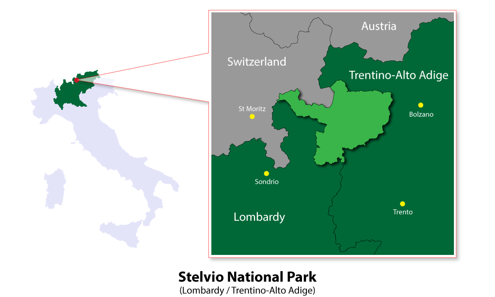
Skip to content
Places / National Parks / Stelvio National Park
Stelvio(Lombardy / Trentino-Alto Adige)

Stelvio
(Lombardy / Trentino-Alto Adige)

Published:

The Stelvio National Park, situated on the borders of the Italian regions of Trentino-Alto Adige, Lombardy, and Switzerland, is the 4th largest national park, by area, in Italy. It was established in 1935 and covers an area of just over 1,300 square kilometres, mostly between 2,000 and 3,000 metres above sea level.

Stelvio National Park
click to enlarge

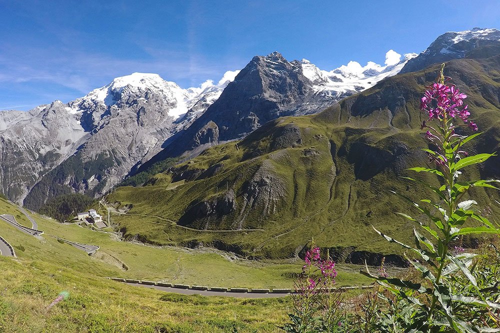
The highest peak is the Ortler at 3,905 metres. The park borders two other national parks: the Swiss National Park to the north and the Adamello National Park to the south. In addition to its spectacular mountain scenery of glaciers, waterfalls, glacial lakes and towering mountain peaks, the national park also offers beautiful valleys, huge forests and many pretty alpine villages and farms.

Stelvio National Park
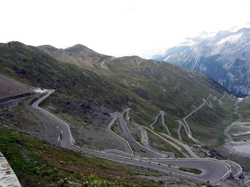
Stelvio Pass - Photo: Amcs1983

The principal valleys in the Stelvio National Park are: Venosta, Martello, Trafoi, Rabbi, Peio and Valtellina. The 'Stelvio Pass' has the reputation of being one of the highest and most spectacular of the Alpine passes to drive down. The Stelvio National Park is dominated by the 'Ortler Alps' mountain range, known as 'Ortles-Cevedale' in Italian and 'Ortler-Alpen' in German.

Stelvio National Park
Ortler ascent - Photo: Noclador

Like all national parks, the area is a haven for all kinds of nature and wildlife. The 'Glacier Buttercup' can be found here. It has the record as being the highest blossoming plant, having been found at 4,275 metres. The area is also home to the Marmot, the Alpine Ibex and the Chamois as well as many species of birds, such as woodpeckers, owls and golden eagles.

Stelvio National Park
Glacier Buttercup - Photo: Alinja

Places Dossier

Places icon

Italy

A compact place-reference: regions, settlements, landscapes, protected areas, and heritage — designed to sit beneath articles.

Regions Towns & Cities Landscapes Heritage
Italy — places feature image
Italy by territory: how the country breaks down, what to look for, and how landscapes and heritage shape the map.

Italy — places snapshot

Stable reference signals for quick geographic orientation.

Regions

20

Five have special autonomous status, reflecting distinct languages, history, and geography. Regions shape administration, services, and identity — often the most useful “map unit” for travellers and readers.

2nd-level

110

Provinces and metropolitan city authorities that coordinate planning, roads, schools, and territorial services. The role varies by area, but they remain a key layer between region and comune.

Comuni

7,904

The municipal building blocks of Italy — cities, towns, villages, and mountain communities. Local identity is strongly comune-based, and many services and permissions are handled at this level.

National parks

25

State-level protected areas covering alpine massifs, forests, volcanic zones, islands, and coastlines. They anchor biodiversity protection and define some of Italy’s most distinctive natural landscapes.

Highest peak

~4,806 m

Mont Blanc (Monte Bianco) on the border with France — the highest summit in the Alps. Italy’s high mountains influence climate, watersheds, and seasonal travel patterns across the north.

Largest lake

~370 km²

Lake Garda, spanning multiple regions, is the largest Italian lake by surface area. Northern lakes act as microclimate zones and long-standing settlement and resort corridors.

Longest river

652 km

The Po runs west–east across the northern plain, shaping agriculture, industry, and major transport routes. It defines Italy’s largest lowland system and a dense belt of settlement and production.

UNESCO

61

World Heritage properties spread across historic centres, archaeological sites, cultural landscapes, and natural areas. The density of listed places makes heritage a visible, lived layer of the national territory.

Regions

Twenty Italies, one map

Regions are the primary lens for variation: dialects, food cultures, building styles, and everyday rhythms often track regional boundaries. They also structure administration and public services, so “where you are” has practical effects as well as cultural ones. For orientation, region is often the fastest way to understand the landscape, the cuisine, and the character of a place.

Towns & Cities

A network of centres

Italy is organised as a network of historic cities and thousands of comuni rather than a single dominant urban core. Larger cities concentrate infrastructure and institutions, while smaller towns preserve local craft, festivals, and distinctive street patterns. This creates short-distance variety: a few kilometres can shift language, architecture, food, and landscape.

Landscapes

Mountains, plains, coasts

The Alps and Apennines frame the country, with plains, lakes, islands, and long coastlines producing sharp local contrasts. Terrain shapes climate, agriculture, and settlement density — and it also governs travel time far more than straight-line distance suggests. Italy’s landscape is best read as a mosaic of micro-regions, each with its own feel and seasonal rhythm.

Heritage

Layers you can visit

Heritage in Italy is embedded: Roman routes, medieval walls, and Renaissance centres are often part of living neighbourhoods. Archaeology appears both as major sites and as fragments — a column, a gate, a street plan — folded into modern life. The experience is less “museum-only” and more a continuous encounter with past layers in active places.

Italy regions
Regions
Italy towns and cities
Towns & Cities
Italy landscapes
Landscapes
Italy heritage sites
Heritage
Italy national parks, lakes, rivers and mountains

Natural

Parks, peaks, water, islands

Italy’s protected landscapes range from alpine ridgelines and deep forests to volcanic terrain and island coastlines. National parks anchor biodiversity and define some of the country’s most iconic routes and viewpoints, while lakes and rivers organise settlement and mobility corridors. The natural map explains climate shifts, local agriculture, and why certain places became historic crossroads, resort zones, or remote refuges.

Italy archaeological sites

Archaeology

From ruins to living streets

Archaeology in Italy is geographic: Greek colonies in the south, Etruscan centres in central regions, Roman infrastructure nationwide, and medieval layers almost everywhere. Some sites are monumental, but many traces appear as everyday fragments — walls, gates, amphitheatres, road alignments — integrated into modern towns. This is why “place” in Italy often includes time: landscapes and settlements carry multiple eras in the same view.