Skip to content
Places / National Parks / Val Grande National Park
Val Grande
Mara Piraglia, CC BY-SA 4.0 <https://creativecommons.org/licenses/by-sa/4.0>, via Wikimedia Commons

Val Grande

Published:

The Parco Nazionale della Val Grande (or Val Grande National Park) is a protected wilderness in Piedmont, northern Italy. The park is the largest wilderness in Europe, at just under 15,000 hectares. The wilderness lies on the border of Switzerland and stretches from Lake Maggiore to the Alps.

Val Grande National Park
click to enlarge

Val Grande has no roads or settled population, with few man-made structures. Over half a century has passed with no human habitation with evidence that nature is slowly reclaiming the natural environment.

It is not a conventional National Park. Walking trails are steep and there is hardly any signage, meaning visitors must rely on maps. Overnight campers bring sleeping bags or choose to stay in some of the abandoned mountain huts peppered around the park. However, please do note that it’s almost impossible to use mobile phones.

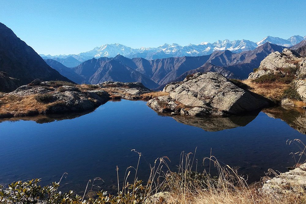
The park is protected, with many fascinating species calling Val Grande their home. The Eurasian eagle owl, rare beetles and even vipers live in the park. Colossal beech trees and conifers are a feature of the park. Closer towards altitude, you can spot Alpine columbine, rhododendrons, wolf’s bane and Alpine tulips.

It is hard to pinpoint the origins of Val Grande, although there is evidence of carvings and objects dating back to the Roman and Iron Ages. Pre-1000, is is assumed that the wilderness was visited by hunters, although it was far too inhabitable for settlers.

From the 10th century, surrounding communities began a process of deforesting the uncultivated land around the valley. From the 14th century, they decided to capitalise on the clearing of the forests by monetising the process. This was led by both a desire to make the land more habitable, as well as the discovery of the Candoglia pink marble quarries, which were mined to help in the construction of the Cathedral of Milan.

Shortly thereafter, timber production grew in the area and became a vital export of the land. Towards the end of the 19th century, Swiss businessman Carlo Sutermeister ran a timber business in the hamlet of Pogallo, housing hundreds of his workforce in little stone buildings near the power plant and the mansion he built for himself.

By the 1900s, the area remained mainly a mystery to most Italians, although small clusters of groups did in fact now call the wilderness home. Although, it was with the arrival of the Second World War that life in the park changed forever. Partisan fighters sought refuge in the wilderness; however, in June 1944, Nazi Germans ransacked the valley, executing dozens of soldiers. When Nazi forces finally broke through Italian borders, the remaining soldiers fled for their lives over the nearby Swiss mountains.

Since then, the wilderness has remained abandoned, however, efforts were made to ensure Val Grande was not forgotten about. In 1967, the area and its growing fauna and flora, enhanced in the absence of humans, was declared a Strict Nature Preserve. In the 1980s, a non-profit organisation acted on plans to turn the area into a National Park. In 1992, the park was officially declared open.

Places Dossier

Places icon

Italy

A compact place-reference: regions, settlements, landscapes, protected areas, and heritage — designed to sit beneath articles.

Regions Towns & Cities Landscapes Heritage
Italy — places feature image
Italy by territory: how the country breaks down, what to look for, and how landscapes and heritage shape the map.

Italy — places snapshot

Stable reference signals for quick geographic orientation.

Regions

20

Five have special autonomous status, reflecting distinct languages, history, and geography. Regions shape administration, services, and identity — often the most useful “map unit” for travellers and readers.

2nd-level

110

Provinces and metropolitan city authorities that coordinate planning, roads, schools, and territorial services. The role varies by area, but they remain a key layer between region and comune.

Comuni

7,904

The municipal building blocks of Italy — cities, towns, villages, and mountain communities. Local identity is strongly comune-based, and many services and permissions are handled at this level.

National parks

25

State-level protected areas covering alpine massifs, forests, volcanic zones, islands, and coastlines. They anchor biodiversity protection and define some of Italy’s most distinctive natural landscapes.

Highest peak

~4,806 m

Mont Blanc (Monte Bianco) on the border with France — the highest summit in the Alps. Italy’s high mountains influence climate, watersheds, and seasonal travel patterns across the north.

Largest lake

~370 km²

Lake Garda, spanning multiple regions, is the largest Italian lake by surface area. Northern lakes act as microclimate zones and long-standing settlement and resort corridors.

Longest river

652 km

The Po runs west–east across the northern plain, shaping agriculture, industry, and major transport routes. It defines Italy’s largest lowland system and a dense belt of settlement and production.

UNESCO

61

World Heritage properties spread across historic centres, archaeological sites, cultural landscapes, and natural areas. The density of listed places makes heritage a visible, lived layer of the national territory.

Regions

Twenty Italies, one map

Regions are the primary lens for variation: dialects, food cultures, building styles, and everyday rhythms often track regional boundaries. They also structure administration and public services, so “where you are” has practical effects as well as cultural ones. For orientation, region is often the fastest way to understand the landscape, the cuisine, and the character of a place.

Towns & Cities

A network of centres

Italy is organised as a network of historic cities and thousands of comuni rather than a single dominant urban core. Larger cities concentrate infrastructure and institutions, while smaller towns preserve local craft, festivals, and distinctive street patterns. This creates short-distance variety: a few kilometres can shift language, architecture, food, and landscape.

Landscapes

Mountains, plains, coasts

The Alps and Apennines frame the country, with plains, lakes, islands, and long coastlines producing sharp local contrasts. Terrain shapes climate, agriculture, and settlement density — and it also governs travel time far more than straight-line distance suggests. Italy’s landscape is best read as a mosaic of micro-regions, each with its own feel and seasonal rhythm.

Heritage

Layers you can visit

Heritage in Italy is embedded: Roman routes, medieval walls, and Renaissance centres are often part of living neighbourhoods. Archaeology appears both as major sites and as fragments — a column, a gate, a street plan — folded into modern life. The experience is less “museum-only” and more a continuous encounter with past layers in active places.

Italy regions
Regions
Italy towns and cities
Towns & Cities
Italy landscapes
Landscapes
Italy heritage sites
Heritage
Italy national parks, lakes, rivers and mountains

Natural

Parks, peaks, water, islands

Italy’s protected landscapes range from alpine ridgelines and deep forests to volcanic terrain and island coastlines. National parks anchor biodiversity and define some of the country’s most iconic routes and viewpoints, while lakes and rivers organise settlement and mobility corridors. The natural map explains climate shifts, local agriculture, and why certain places became historic crossroads, resort zones, or remote refuges.

Italy archaeological sites

Archaeology

From ruins to living streets

Archaeology in Italy is geographic: Greek colonies in the south, Etruscan centres in central regions, Roman infrastructure nationwide, and medieval layers almost everywhere. Some sites are monumental, but many traces appear as everyday fragments — walls, gates, amphitheatres, road alignments — integrated into modern towns. This is why “place” in Italy often includes time: landscapes and settlements carry multiple eras in the same view.