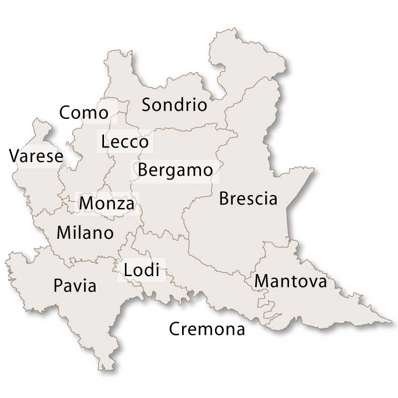
The large province of Bergamo lies in the centre of the region of Lombardy and covers an area of 2,745.94 sq.km. It borders the province of Sondrio to the north, the province of Brescia to the east, the provinces of Milano, Monza & Brianza and Lecco to the west and the province of Cremona to the south.
Find a hotel in Lombardy

Province of Bergamo, Lombardy
The nothern portion of this province is mountainous with the highest peak being Mount Coca at 3052 metres. Moving southwards the province gradually flattens out and the lower lying areas are fertile and rich providing a perfect environment for the production of corn, rice and other grains.
The capital city of the province is Bergamo with the second city being Treviglio.
Other main towns in the province of Bergamo are:
- Seriate
- Dalmine
- Romano di Lombardia
- Albino
- Caravaggio
- Alzano Lombardo
- Stezzano
- Osio Sotto
Nestled in the northern region of Italy, Bergamo Province is a gem of Lombardy, blending rich historical heritage with breathtaking natural beauty. Known for its picturesque landscapes, medieval architecture, and vibrant culture, Bergamo has something to offer every traveler—from art and history enthusiasts to nature lovers and food aficionados. The province's diverse offerings, from the Alps to its historic towns, make it a unique destination in Italy’s diverse geographical and cultural tapestry.
Historical Overview
Bergamo has a long and fascinating history that dates back to ancient times. Originally a settlement of the Celtic Cenomani tribe, Bergamo was later absorbed into the Roman Empire. The Roman influence shaped the early urban layout of Bergamo city, which eventually became a part of the Lombard kingdom in the early medieval period. During the Middle Ages, Bergamo was a strategic stronghold, and its location at the foot of the Alps made it an important trade and military center.
The city of Bergamo itself is often divided into two distinct areas: the Città Alta (Upper City) and Città Bassa (Lower City). The Città Alta, perched on a hill, is encircled by well-preserved Venetian walls, a testament to the city’s military significance during the Renaissance. For centuries, Bergamo was under Venetian rule, from 1428 to 1797, leaving a lasting legacy of Venetian art, architecture, and culture.
After the Napoleonic era, Bergamo became part of the Austrian Empire and later played a crucial role in the Italian unification process, joining the Kingdom of Italy in 1861. Today, it stands as a cultural and economic hub in the Lombardy region.
The Beauty of Bergamo City: Città Alta and Città Bassa
Bergamo’s urban landscape is defined by its two distinct areas, each offering a unique experience for visitors.
Città Alta (Upper City): This part of Bergamo is a medieval treasure, characterized by narrow cobblestone streets, centuries-old buildings, and panoramic views of the surrounding countryside. Dominated by the Piazza Vecchia, one of the most beautiful squares in Italy, the Città Alta is home to several important historical sites, including the Basilica di Santa Maria Maggiore, a Romanesque church adorned with stunning frescoes, and the Cappella Colleoni, a Renaissance chapel known for its exquisite architecture. The Rocca di Bergamo, a fortress offering sweeping views, is also located here, providing visitors with a glimpse into the city’s military past.
Città Bassa (Lower City): In contrast to the ancient atmosphere of the Città Alta, the Città Bassa is modern and vibrant, with elegant shops, restaurants, and cultural institutions. The Accademia Carrara in the Lower City is one of Italy’s finest art galleries, housing works by Renaissance masters such as Botticelli, Raphael, and Mantegna. The modern lower city is also the heart of Bergamo’s economic activity, offering a blend of historical charm and contemporary life.
Natural Wonders: The Bergamo Alps and Valleys
Bergamo Province is also known for its natural beauty, with the Bergamo Alps forming an impressive backdrop. The mountains offer excellent opportunities for outdoor activities, particularly hiking, skiing, and mountain biking. Some of the most popular mountain destinations include Val Seriana, Val Brembana, and Valle Imagna, all offering stunning landscapes and a chance to explore traditional alpine villages.
Val Seriana is famous for its beautiful trails and natural parks. One of the key highlights is the Orobie Bergamasche Park, which protects the alpine environment and offers trails that cater to both seasoned hikers and casual walkers.
Val Brembana is another popular area, known for its historical spa town of San Pellegrino Terme, home to the famous San Pellegrino mineral water. The town’s elegant Liberty-style architecture and thermal baths attract visitors looking for relaxation in a picturesque setting.
Valle Imagna, less frequented by tourists, offers a more tranquil experience, with lush valleys and pristine nature. It’s an ideal destination for those who prefer off-the-beaten-path locations.
Rich Cultural and Culinary Traditions
Bergamo's culture is deeply influenced by its history and geographical location. While firmly rooted in Lombardy, Bergamo’s proximity to Venice has left a significant cultural mark. Festivals and traditions are celebrated with enthusiasm throughout the year, blending ancient customs with modern events.
One of the most notable cultural events is the Bergamo Film Meeting, an international film festival that has been held annually since 1983, drawing filmmakers and enthusiasts from around the world.
In terms of cuisine, Bergamo is renowned for its traditional dishes that showcase the flavors of Lombardy. Polenta, a cornmeal-based dish, is a staple of Bergamo’s culinary heritage, often served with stews, sausages, or cheese. The province is also famous for its casoncelli, a type of stuffed pasta, typically filled with meat, cheese, and breadcrumbs, served with melted butter and sage.
Another regional specialty is the Taleggio cheese, a soft, pungent cheese produced in the valleys of Bergamo. Paired with local wines such as Valcalepio, Bergamo’s culinary delights are a highlight for food lovers.
Notable Towns and Villages
While the city of Bergamo is the focal point of the province, the surrounding towns and villages also offer rich experiences. Each town boasts its own charm, history, and connection to the region’s traditions.
Clusone, situated in the Val Seriana, is known for its medieval frescoes and the Orologio Fanzago, an astronomical clock that has been ticking since the 16th century.
San Pellegrino Terme, mentioned earlier, is a spa town known for its thermal baths and iconic Liberty-style architecture.
Sarnico and Lovere, located on the shores of Lake Iseo, are charming lakeside towns offering tranquil settings and beautiful views.
Conclusion
Bergamo Province is a captivating blend of history, culture, and natural beauty. From the medieval streets of Città Alta to the tranquil valleys of the Bergamo Alps, the province offers a rich array of experiences for travelers. Its art, architecture, and culinary traditions make it a unique and unforgettable destination in northern Italy. Whether exploring its ancient churches, indulging in local delicacies, or hiking through its picturesque landscapes, Bergamo is a province that rewards exploration and leaves visitors with lasting memories of its timeless charm.


