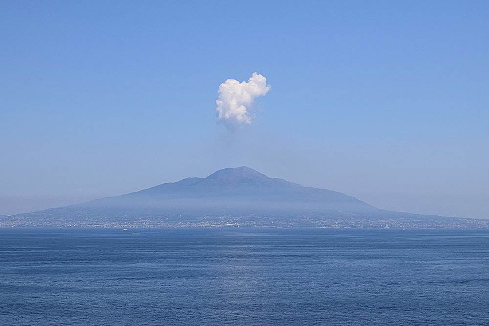
Skip to content
Places / National Parks / Vesuvio National Park
Vesuvio

Vesuvio

Published:

The Vesuvius National Park was created in June, 1995, to protect the area around the volcano, together with the rich variety of animal and plant species that can be found there. It covers an area of 135 square kilometres around Mount Vesuvius and lies totally within the province of Naples, in the region of Campania.

Vesuvius National Park
clisk to enlarge

Mount Vesuvius itself is one of the best known and most studied volcanoes in the world. Its distinct shape can be immediately recognised and has come to symbolise the city of Naples. However, that shape is actually made up of two volcanoes, known as the Somma-Vesuvius volcanic complex. Mount Vesuvius is actually a volcano within a volcano. The outer, broken cone is Mount Somma, now extinct, with the active volcano, Mount Vesuvius, having formed within its crater, probably during the eruption that destroyed Pompei in AD 79.

Mount Vesuvius at its highest point is 1,277 metres and the crater currently has a diameter of 450 metres and a depth of 300 metres. The Vesuvius National Park is also home to 612 plant species and 227 animal species.

One of the most dramatic aspects of the Vesuvius National Park is the opportunity to walk up the side of Mount Vesuvious and look into the crater of an active volcano! The crater is called 'Il Gran Cono'. Visitors initially arrive at the 'Piazzale', or 'Square' which is at an altitude of 1,000 metres. It can be reached by car, bus or train and there is a Visitor Centre that provides useful information and sells maps.

After buying a ticket, it is a relatively easy walk of about 800 metres to the edge of the crater. Throughout the trip, there are spectacular views of the 'Valle del Gigante', the plain that separates Mount Vesuvious from the crater of Mount Somma. You can also see across much of the region of Campania and into Lazio.

In addition to the Volcano itself. the Vesuvius area is home to many historic and cultural experiences. The most well-known are the ruins of Pompei and Herculaneam where visitors can stroll around the Roman towns and imagine what life was like before the fateful eruption of AD 79.

The 'Antiquarium of Herculaneum' is an enhancement of the visit to the ruins, it collects artefacts and statues from Pompei and Herculaneum.

Nearby is the 'MAV' The 'Virtual Archaeological Museum of Herculaneum'. One of the most modern museums in Italy, and located close to the archaeological excavations, it offers over 70 multimedia installations bringing the main archaeological sites of Pompei, Herculaneum, Baia, Stabia and Capri back to life and splendour.

Official website

The eruption of Mount Vesuvius in AD 79 released energy 100,000 times greater than that created by the atomic bombs of Hiroshima and Nagasaki. More than 1,000 people died in the cities of Pompeii, Herculaneum, Oplontis and Stabiae, as well other settlements in the surrounding area. A cloud of stones, ash and volcanic gas reached a height of over 30 kilomentres. Although there were many other eruptions before AD 79, several of them more powerful, we know more about that one through the writings of Pliny the Younger, who witnessed the destruction of Pompei from the northern end of the Bay of Naples. This particular type of volcanic eruption is called 'Plinian' after his influence.

Vesuvius has erupted many times since, but none of the eruptions have been as powerful. The most recent eruption was in 1944. At the time, the United States Army Airforces were based at Pompeii Airfield near Terzigno, a few kilometres from the eastern base of the volcano. More than 80 aircraft were destroyed.

Today, Mount Vesuvius is regarded as one of the most dangerous volcanoes in the world because more than three million people live near enough to be affected, and more than half a million living in the immediate danger zone. This makes it the most densely populated volcanic region in the world. Vesuvius also has a tendency for violent, explosive eruptions of the 'Plinian' type.

Places Dossier

Places icon

Italy

A compact place-reference: regions, settlements, landscapes, protected areas, and heritage — designed to sit beneath articles.

Regions Towns & Cities Landscapes Heritage
Italy — places feature image
Italy by territory: how the country breaks down, what to look for, and how landscapes and heritage shape the map.

Italy — places snapshot

Stable reference signals for quick geographic orientation.

Regions

20

Five have special autonomous status, reflecting distinct languages, history, and geography. Regions shape administration, services, and identity — often the most useful “map unit” for travellers and readers.

2nd-level

110

Provinces and metropolitan city authorities that coordinate planning, roads, schools, and territorial services. The role varies by area, but they remain a key layer between region and comune.

Comuni

7,904

The municipal building blocks of Italy — cities, towns, villages, and mountain communities. Local identity is strongly comune-based, and many services and permissions are handled at this level.

National parks

25

State-level protected areas covering alpine massifs, forests, volcanic zones, islands, and coastlines. They anchor biodiversity protection and define some of Italy’s most distinctive natural landscapes.

Highest peak

~4,806 m

Mont Blanc (Monte Bianco) on the border with France — the highest summit in the Alps. Italy’s high mountains influence climate, watersheds, and seasonal travel patterns across the north.

Largest lake

~370 km²

Lake Garda, spanning multiple regions, is the largest Italian lake by surface area. Northern lakes act as microclimate zones and long-standing settlement and resort corridors.

Longest river

652 km

The Po runs west–east across the northern plain, shaping agriculture, industry, and major transport routes. It defines Italy’s largest lowland system and a dense belt of settlement and production.

UNESCO

61

World Heritage properties spread across historic centres, archaeological sites, cultural landscapes, and natural areas. The density of listed places makes heritage a visible, lived layer of the national territory.

Regions

Twenty Italies, one map

Regions are the primary lens for variation: dialects, food cultures, building styles, and everyday rhythms often track regional boundaries. They also structure administration and public services, so “where you are” has practical effects as well as cultural ones. For orientation, region is often the fastest way to understand the landscape, the cuisine, and the character of a place.

Towns & Cities

A network of centres

Italy is organised as a network of historic cities and thousands of comuni rather than a single dominant urban core. Larger cities concentrate infrastructure and institutions, while smaller towns preserve local craft, festivals, and distinctive street patterns. This creates short-distance variety: a few kilometres can shift language, architecture, food, and landscape.

Landscapes

Mountains, plains, coasts

The Alps and Apennines frame the country, with plains, lakes, islands, and long coastlines producing sharp local contrasts. Terrain shapes climate, agriculture, and settlement density — and it also governs travel time far more than straight-line distance suggests. Italy’s landscape is best read as a mosaic of micro-regions, each with its own feel and seasonal rhythm.

Heritage

Layers you can visit

Heritage in Italy is embedded: Roman routes, medieval walls, and Renaissance centres are often part of living neighbourhoods. Archaeology appears both as major sites and as fragments — a column, a gate, a street plan — folded into modern life. The experience is less “museum-only” and more a continuous encounter with past layers in active places.

Italy regions
Regions
Italy towns and cities
Towns & Cities
Italy landscapes
Landscapes
Italy heritage sites
Heritage
Italy national parks, lakes, rivers and mountains

Natural

Parks, peaks, water, islands

Italy’s protected landscapes range from alpine ridgelines and deep forests to volcanic terrain and island coastlines. National parks anchor biodiversity and define some of the country’s most iconic routes and viewpoints, while lakes and rivers organise settlement and mobility corridors. The natural map explains climate shifts, local agriculture, and why certain places became historic crossroads, resort zones, or remote refuges.

Italy archaeological sites

Archaeology

From ruins to living streets

Archaeology in Italy is geographic: Greek colonies in the south, Etruscan centres in central regions, Roman infrastructure nationwide, and medieval layers almost everywhere. Some sites are monumental, but many traces appear as everyday fragments — walls, gates, amphitheatres, road alignments — integrated into modern towns. This is why “place” in Italy often includes time: landscapes and settlements carry multiple eras in the same view.