Skip to content
Places / Islands / Tremiti Islands
Tremiti Islands
Carmen Fiano, PDM-owner, via Wikimedia Commons

Tremiti Islands

Published:

The Tremiti islands are located in the Adriatic sea, off the northern coast of the province of Foggia in Puglia. The archipelago consists of five small islands: San Dòmino, San Nicola, Cretaccio, Capraia and Pianosa, and are part of the Gargano National Park. Their solitude and the clear blue water that surrounds them attracts more than 100,000 visitors a year who arrive on ferries from the ports of: Termoli, Foggia, Vieste, Rodi Garganico and Capoiale.

Tremiti islands, san domino, san nicola, cretaccio, capraia, pianosa

San Dòmino

The largest island is San Dòmino. It is 2,600 metres long and 1,700 metres wide with a total area of just over 2 square kilometres.

Tremiti islands, san domino, san nicola, cretaccio, capraia, pianosa
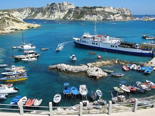
Harbour at San Dòmino
Roby Ferrari, CC BY-SA 2.0 , da Wikimedia Commons

The highest point is just over 100 metres. It is the nearest island to the Gargano Peninsula and is the main tourist attraction. It has a population of around 250 people.
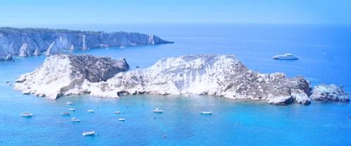
San Nicola

450 metres to the north east lies the island of San Nicola. 1,600 metres long and 450 metres wide, it has a total area of just under half a square kilometre. The highest point is 75 metres. It has a population of around 150 people.

Tremiti islands, san domino, san nicola, cretaccio, capraia, pianosa
San Nicola
Ra Boe / Wikipedia, CC BY-SA 3.0 DE , via Wikimedia Commons

Cretaccio

The island of Cretaccio, lying between San Dòmino and San Nicola, is little more than a rock and is uninhabited.

Tremiti islands, san domino, san nicola, cretaccio, capraia, pianosa
Cretaccio
Carmen Fiano, PDM-owner, via Wikimedia Commons

Capraia

The island of Capraia, named after its population of wild goats, is the same size as San Nicola but is uninhabited.

Tremiti islands, san domino, san nicola, cretaccio, capraia, pianosa
Capraia
Bultro, CC BY-SA 3.0 , da Wikimedia Commons

Pianosa

The island of Pianosa lies away from the main group, 20 nautical miles from the Italian coast. It is 700 metres long, 250 metres wide and only 15 metres high. It has a total area of only 13 hectares (32 acres) and is also uninhabited.

Tremiti islands, san domino, san nicola, cretaccio, capraia, pianosa
Pianosa
Matteo Vinattieri, CC BY 3.0 httpscreativecommons.orglicensesby3.0, da Wikimedia Commons

One explanation of the name, 'Tremiti', is that it refers to the frequent earth tremors and the islands' long history of earthquakes, although another explanation is that it refers to the Greek, 'Trimeros', meaning 'Tree Islands'. Whatever the origins of the name, the islands have had a very long history and have been inhabited since the 4th century BC.

An abbey, Santa Maria a Mare (Holy Mary on the Sea), was established on the island of San Nicola around the 9th century by Benedictine monks. Politics and piracy led to the decline and eventual destruction of the abbey in the 13th century. In the 15th century, the abbey was restored and fortified to the extent that it withstood an attack by the Ottomans in 1567.

During the 18th century, the islands became a penal colony under the king of Sicily, Ferdinand IV. Mussolini also used the islands as a prison camp when he deported hundreds of homosexuals and interned them there in the period before the second world war.

In 2012, the islands became involved in scandal when the local government tried to sell off some of the land for several millions of euros. The locals were outraged, but it all came to nothing as there were no bidders!

So, for now, the Tremiti islands continue to be a favourite destination for those holiday makers who have discovered them...

Places Dossier

Places icon

Italy

A compact place-reference: regions, settlements, landscapes, protected areas, and heritage — designed to sit beneath articles.

Regions Towns & Cities Landscapes Heritage
Italy — places feature image
Italy by territory: how the country breaks down, what to look for, and how landscapes and heritage shape the map.

Italy — places snapshot

Stable reference signals for quick geographic orientation.

Regions

20

Five have special autonomous status, reflecting distinct languages, history, and geography. Regions shape administration, services, and identity — often the most useful “map unit” for travellers and readers.

2nd-level

110

Provinces and metropolitan city authorities that coordinate planning, roads, schools, and territorial services. The role varies by area, but they remain a key layer between region and comune.

Comuni

7,904

The municipal building blocks of Italy — cities, towns, villages, and mountain communities. Local identity is strongly comune-based, and many services and permissions are handled at this level.

National parks

25

State-level protected areas covering alpine massifs, forests, volcanic zones, islands, and coastlines. They anchor biodiversity protection and define some of Italy’s most distinctive natural landscapes.

Highest peak

~4,806 m

Mont Blanc (Monte Bianco) on the border with France — the highest summit in the Alps. Italy’s high mountains influence climate, watersheds, and seasonal travel patterns across the north.

Largest lake

~370 km²

Lake Garda, spanning multiple regions, is the largest Italian lake by surface area. Northern lakes act as microclimate zones and long-standing settlement and resort corridors.

Longest river

652 km

The Po runs west–east across the northern plain, shaping agriculture, industry, and major transport routes. It defines Italy’s largest lowland system and a dense belt of settlement and production.

UNESCO

61

World Heritage properties spread across historic centres, archaeological sites, cultural landscapes, and natural areas. The density of listed places makes heritage a visible, lived layer of the national territory.

Regions

Twenty Italies, one map

Regions are the primary lens for variation: dialects, food cultures, building styles, and everyday rhythms often track regional boundaries. They also structure administration and public services, so “where you are” has practical effects as well as cultural ones. For orientation, region is often the fastest way to understand the landscape, the cuisine, and the character of a place.

Towns & Cities

A network of centres

Italy is organised as a network of historic cities and thousands of comuni rather than a single dominant urban core. Larger cities concentrate infrastructure and institutions, while smaller towns preserve local craft, festivals, and distinctive street patterns. This creates short-distance variety: a few kilometres can shift language, architecture, food, and landscape.

Landscapes

Mountains, plains, coasts

The Alps and Apennines frame the country, with plains, lakes, islands, and long coastlines producing sharp local contrasts. Terrain shapes climate, agriculture, and settlement density — and it also governs travel time far more than straight-line distance suggests. Italy’s landscape is best read as a mosaic of micro-regions, each with its own feel and seasonal rhythm.

Heritage

Layers you can visit

Heritage in Italy is embedded: Roman routes, medieval walls, and Renaissance centres are often part of living neighbourhoods. Archaeology appears both as major sites and as fragments — a column, a gate, a street plan — folded into modern life. The experience is less “museum-only” and more a continuous encounter with past layers in active places.

Italy regions
Regions
Italy towns and cities
Towns & Cities
Italy landscapes
Landscapes
Italy heritage sites
Heritage
Italy national parks, lakes, rivers and mountains

Natural

Parks, peaks, water, islands

Italy’s protected landscapes range from alpine ridgelines and deep forests to volcanic terrain and island coastlines. National parks anchor biodiversity and define some of the country’s most iconic routes and viewpoints, while lakes and rivers organise settlement and mobility corridors. The natural map explains climate shifts, local agriculture, and why certain places became historic crossroads, resort zones, or remote refuges.

Italy archaeological sites

Archaeology

From ruins to living streets

Archaeology in Italy is geographic: Greek colonies in the south, Etruscan centres in central regions, Roman infrastructure nationwide, and medieval layers almost everywhere. Some sites are monumental, but many traces appear as everyday fragments — walls, gates, amphitheatres, road alignments — integrated into modern towns. This is why “place” in Italy often includes time: landscapes and settlements carry multiple eras in the same view.