Skip to content
Places / Islands / Pontine Islands
Pontine Islands

Pontine Islands

Published:

The Pontine Islands are located in the Tyrrhenian Sea off the coast of Campania, although they are a part of Lazio. The Pontine archipelago consists of six islands: Palmarola, Ponza, Gavi, Zanone, Ventotene and Santo Stefano, which are spread over a distance of 22 nautical miles.

Find hotels in the Pontine Islands

Ponza and Ventotene are the only two that are inhabited. Palmarola is a favourite boating destination and has a landing stage and a restaurant open in the summer months. Zanone is a nature reserve but can be visited by boat and Gavi is privately owned and mainly inhabited by rabbits! Ponza and Gavi, the small island to the north, owe their distinctive shape to being formed from the remains of an extinct volcano.

The Pontine Islands, Ponza, Palmarola, Ventotene, Santo Stefano, Gavi, Zanone

Ponza

Ponza is the largest of the Pontine islands with a total area of 7.3 square kilometres. It is approximately 8.9 km long by 2.4 km wide at its widest point.

The Pontine Islands, Ponza, Palmarola, Ventotene, Santo Stefano, Gavi, Zanone
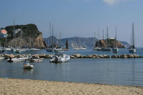
Ponza harbour - Photo: www.understandingitaly.com

Originally colonised in prehistoric times, it was developed by the Etruscans and then the Romans but abandoned during the middle ages due to constant pirate attack. The island now has a flourishing tourist industry. Ferries from the mainland arrive into the pretty little harbour on the island's east side, packed with Italians who flock there on day trips during the summer months.

But Ponza is more than just a holiday island. It boasts a rich and colourful history, full of myths and legends, even if the truth of some of the stories is dubious. The first concerns the island's name. It is said to be named after Pontius Pilate, the Roman governor of Judea, responsible for sentencing Jesus to death. His family owned land on Ponza and there is a cave named after him.

The Pontine Islands, Ponza, Palmarola, Ventotene, Santo Stefano, Gavi, Zanone

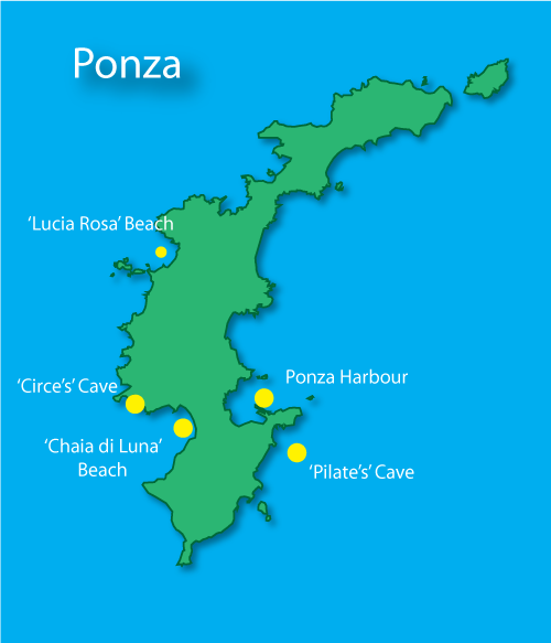
The second story concerns Homer's Odyssey. Ponza is said to be the inspiration for the island of Aeaea, the winter home of Circe the Sorceress. Having turned Odysseus's men into swine, she seduced him and spent a year living with him in a cave near 'Chaia di Luna' beach.

A story probably more based in fact, was that Nero Caesar, Caligula's brother, was banished to Ponza and put to death there in 30 AD for conspiring to overthrow him. Two of his sisters, also involved in the plot, were exiled to Ponza and Ventotene for more than 10 years.

The island, together with Ventotene, served as a penal colony during Mussolini's regime. Ironically, Mussolini himself was held there for a short while just before his death in 1943.

Ponza is also the location for the tragic story of Lucia Rosa. About to be forced to marry someone against her will, she threw herself into the Tyrrhenian Sea, becoming a martyr for women's rights and a symbol for human rights around the world.

Palmarola

Palmarola is the second largest of the Pontine Islands, located 10 km west of the island of Ponza.

It has a rocky coastline with many natural bays that provide safe anchorages, making it extremely popular for visiting yachts and motor boats. There are landing stages and restaurants that cater for visitors during the summer.

Ventotene

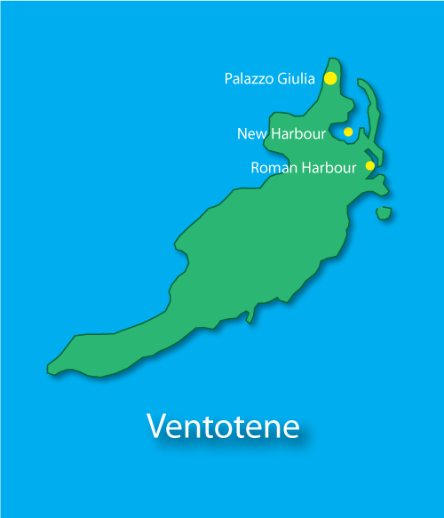
Ventotene, which was called Pandataria in Roman times, is the third largest of the Pontine Islands and, along with Ponza, one of only two that are inhabited. It is 3 km long and only 800 metres wide.

The Pontine Islands, Ponza, Palmarola, Ventotene, Santo Stefano, Gavi, Zanone

Ventotene's main claim to fame is for playing host to a series of banished Romans. In 2 BC, the emperor Augustus banished his daughter, Julia the Elder, to Ventotene because of her 'excessive' adultery.

The Pontine Islands, Ponza, Palmarola, Ventotene, Santo Stefano, Gavi, Zanone
Roman harbour, Ventotene - Photo: www.understandingitaly.com

Later, the emperor Tiberius sent Caligula's mother, Agrippa the Elder to follow in her footsteps and she died on the island in 29 AD. Her daughter, Julia Livilla was exiled there twice, finally dying there herself. The ruins of her mansion can be seen on the 'Eolo' headland, next to the New Harbour.

Finally, the emperor Nero banished his wife, Claudia Octavia, to Ventotene where she was executed soon after 62 AD.

The tiny island of Santo Stefano, located 2 km from Ventotene's east coast, was developed as a prison island by the Bourbons and later used by Mussolini who incarcerated 700 political opponents there during the second world war.

Places Dossier

Places icon

Italy

A compact place-reference: regions, settlements, landscapes, protected areas, and heritage — designed to sit beneath articles.

Regions Towns & Cities Landscapes Heritage
Italy — places feature image
Italy by territory: how the country breaks down, what to look for, and how landscapes and heritage shape the map.

Italy — places snapshot

Stable reference signals for quick geographic orientation.

Regions

20

Five have special autonomous status, reflecting distinct languages, history, and geography. Regions shape administration, services, and identity — often the most useful “map unit” for travellers and readers.

2nd-level

110

Provinces and metropolitan city authorities that coordinate planning, roads, schools, and territorial services. The role varies by area, but they remain a key layer between region and comune.

Comuni

7,904

The municipal building blocks of Italy — cities, towns, villages, and mountain communities. Local identity is strongly comune-based, and many services and permissions are handled at this level.

National parks

25

State-level protected areas covering alpine massifs, forests, volcanic zones, islands, and coastlines. They anchor biodiversity protection and define some of Italy’s most distinctive natural landscapes.

Highest peak

~4,806 m

Mont Blanc (Monte Bianco) on the border with France — the highest summit in the Alps. Italy’s high mountains influence climate, watersheds, and seasonal travel patterns across the north.

Largest lake

~370 km²

Lake Garda, spanning multiple regions, is the largest Italian lake by surface area. Northern lakes act as microclimate zones and long-standing settlement and resort corridors.

Longest river

652 km

The Po runs west–east across the northern plain, shaping agriculture, industry, and major transport routes. It defines Italy’s largest lowland system and a dense belt of settlement and production.

UNESCO

61

World Heritage properties spread across historic centres, archaeological sites, cultural landscapes, and natural areas. The density of listed places makes heritage a visible, lived layer of the national territory.

Regions

Twenty Italies, one map

Regions are the primary lens for variation: dialects, food cultures, building styles, and everyday rhythms often track regional boundaries. They also structure administration and public services, so “where you are” has practical effects as well as cultural ones. For orientation, region is often the fastest way to understand the landscape, the cuisine, and the character of a place.

Towns & Cities

A network of centres

Italy is organised as a network of historic cities and thousands of comuni rather than a single dominant urban core. Larger cities concentrate infrastructure and institutions, while smaller towns preserve local craft, festivals, and distinctive street patterns. This creates short-distance variety: a few kilometres can shift language, architecture, food, and landscape.

Landscapes

Mountains, plains, coasts

The Alps and Apennines frame the country, with plains, lakes, islands, and long coastlines producing sharp local contrasts. Terrain shapes climate, agriculture, and settlement density — and it also governs travel time far more than straight-line distance suggests. Italy’s landscape is best read as a mosaic of micro-regions, each with its own feel and seasonal rhythm.

Heritage

Layers you can visit

Heritage in Italy is embedded: Roman routes, medieval walls, and Renaissance centres are often part of living neighbourhoods. Archaeology appears both as major sites and as fragments — a column, a gate, a street plan — folded into modern life. The experience is less “museum-only” and more a continuous encounter with past layers in active places.

Italy regions
Regions
Italy towns and cities
Towns & Cities
Italy landscapes
Landscapes
Italy heritage sites
Heritage
Italy national parks, lakes, rivers and mountains

Natural

Parks, peaks, water, islands

Italy’s protected landscapes range from alpine ridgelines and deep forests to volcanic terrain and island coastlines. National parks anchor biodiversity and define some of the country’s most iconic routes and viewpoints, while lakes and rivers organise settlement and mobility corridors. The natural map explains climate shifts, local agriculture, and why certain places became historic crossroads, resort zones, or remote refuges.

Italy archaeological sites

Archaeology

From ruins to living streets

Archaeology in Italy is geographic: Greek colonies in the south, Etruscan centres in central regions, Roman infrastructure nationwide, and medieval layers almost everywhere. Some sites are monumental, but many traces appear as everyday fragments — walls, gates, amphitheatres, road alignments — integrated into modern towns. This is why “place” in Italy often includes time: landscapes and settlements carry multiple eras in the same view.