River Arno
The River Arno, stretching over 241 kilometers (150 miles), is one of Italy’s most important waterways. It flows through the heart of Tuscany, touching some of the region’s most iconic cities and landscapes. Beginning in the Apennine Mountains, the Arno descends through valleys and cities rich in history and culture before reaching its mouth at the Ligurian Sea.
Source and Path of the Arno
The Arno’s journey begins at Monte Falterona, a peak in the Casentino region of the Apennine mountain range, situated in the Tuscan province of Arezzo. From here, it winds its way westward, passing through Florence, Empoli, and Pisa, the three most significant cities along its path. The river’s flow can be unpredictable, with frequent floods in the past that have shaped the cities along its banks.
Historical Importance
The River Arno has played a crucial role in the development of Tuscany since antiquity. It provided a lifeline for trade and commerce, particularly for Florence during the Renaissance. Florence grew in prosperity due to its strategic location on the Arno, which allowed it to become a hub for merchants and artists alike.
In medieval times, the river enabled trade routes that connected Florence to Pisa, one of Italy's prominent maritime republics, facilitating the transport of goods like wool, grain, and fine fabrics. Pisa's port at the mouth of the Arno was once a gateway for trade between Tuscany and the Mediterranean.
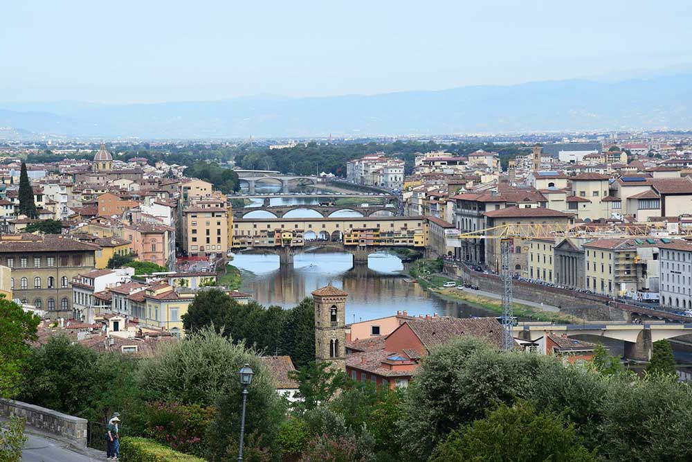
Florence and the Arno: A Symbiotic Relationship
Perhaps the most famous city along the Arno is Florence, whose identity is intertwined with the river. The Ponte Vecchio, a medieval stone bridge over the Arno, is one of Florence's most iconic landmarks. Built in 1345, it houses shops traditionally occupied by goldsmiths and jewelers. Despite floods, wars, and time, the bridge has stood firm, a symbol of Florence’s resilience.
Florence's Renaissance-era architecture, including the Uffizi Gallery, Palazzo Vecchio, and Basilica of Santa Croce, hugs the river, making the Arno a scenic counterpart to the city’s cultural treasures. The river is a beloved subject for artists, depicted in countless works of art that highlight its serene and often romantic presence within the city.
However, the Arno’s tranquility has sometimes been deceptive. The most infamous flood occurred in 1966, when heavy rains caused the river to overflow, devastating Florence and damaging priceless artworks and historical buildings. The disaster rallied an international effort to save Florence’s heritage, marking a significant chapter in the city’s modern history.
Pisa and the Arno's Maritime Legacy
Further downstream, the Arno flows through Pisa, another city steeped in history. Pisa, with its world-famous Leaning Tower, has always been tied to the sea. During its height as a powerful maritime republic, Pisa relied on the Arno to access the Mediterranean, a crucial advantage for trade and naval prowess.
The river’s silting over the centuries has somewhat diminished Pisa’s role as a maritime power, and today, the Arno no longer reaches the sea through a deep navigable channel. However, its influence on the city’s history is still evident, and the river continues to be a prominent feature of Pisa’s landscape.
Nature and Landscape Along the Arno
The Arno winds through rich, fertile valleys, offering lush landscapes typical of Tuscany. The Val d'Arno region is known for its vineyards, olive groves, and rolling hills. This area has long been a source of agriculture for the region, producing wine, olive oil, and various crops that are central to Tuscan cuisine.
The river's course includes several dams and reservoirs, which have been used for irrigation and hydroelectric power, further enhancing its importance to the region’s economy. Despite industrialization, the river and its surroundings retain a pastoral beauty that continues to attract visitors.
Arno’s Environmental Challenges
Like many rivers, the Arno faces environmental challenges. Urbanization, pollution, and climate change pose risks to the river’s ecosystem. Efforts to preserve the river’s water quality and manage flood risks have been ongoing, but the balance between modernization and conservation remains delicate.
Cultural Influence of the Arno
The River Arno has not only shaped the physical landscape of Tuscany but also its cultural and artistic heritage. Poets, writers, and artists throughout history have drawn inspiration from its tranquil waters. For example, Dante Alighieri references the Arno in his 'Divine Comedy', while artists such as Leonardo da Vinci and Sandro Botticelli have depicted scenes of the Arno in their works.
The river also plays a central role in the Calcio Storico, a traditional Florentine game held annually in Piazza Santa Croce, where rival neighborhoods compete in a mix of soccer, rugby, and wrestling. Though the sport is played away from the river’s banks, the Arno remains an enduring symbol of Florentine pride and tradition.
Conclusion
The River Arno is far more than a body of water, it is a thread woven through the history, culture, and economy of Tuscany. From the bustling streets of Florence to the serene countryside, the Arno remains a witness to centuries of change and progress. Its influence, both practical and symbolic, continues to shape the identity of the region, reminding locals and visitors alike of the power and beauty that flow through the heart of Tuscany.


